Hingol National Park is a testament to Pakistan's natural and cultural heritage. Its unique integration of terrestrial and marine ecosystems, coupled with its rich biodiversity, makes it a site of global significance. By implementing sustainable management practices, involving local communities, and promoting ecotourism, Hingol Serving a model for conservation in the region. It is our collective responsibility to preserve this natural jewel for future generations to cherish Hingol National Park, named after the Hingol River, derives its name from historical and mythological accounts. The river flows centrally through the park, linking diverse habitats such as mountains, valleys, estuaries, sand dunes, and the Arabian Sea. Hingol National Park is the largest national park in Pakistan, featuring both terrestrial and marine ecosystems.
The
Park has a unique setting being the largest National Park in
Hingol
is a natural jewel of Balochistan inhabited by several tribal groups such as
Degarzai, Angaria, Channal, Umradi, Mangiani, Kurd, and Bizanjo. It has unique
features including the centuries old and world renowned pilgrim site of
Hinglaj, magnificient clay mountains and rare mud volcanoes, a diverse coast
with sand dunes, salt flat, estuary, beaches, rock headlands and the Arabian
Sea.
The park was established in 1988, consolidating areas including the
Dhrun Wildlife Sanctuary, Hingol area, and the intervening Rodani-Kacho and
Northern Plains. The park's marine zone was later expanded in 1997, extending
to waters up to 9 meters deep. The terrestrial area spans approximately 625,000
hectares, and the marine zone covers 47,000 hectares.
Geographical and Ecological Significance
Hingol's unique setting is defined by its diverse habitats, which
include mountains, valleys, riverine systems, coastal dunes, estuaries, and the
Arabian Sea. Central to its ecosystem is the Hingol River, the largest river
outside the Indus system, which serves as a lifeline for the park's wildlife
and the communities residing within its boundaries.
The park lies at the convergence of three zoogeographical regions:
- African
(Ethiopian) Region: Home
to species like Chinkara gazelle, sandgrouse, and Acacia senegal.
- Palarctic
Region: Supporting Afghan
Urial, Sindh Ibex, and winter migratory birds such as the Houbara Bustard.
- Oriental
Region: Habitats for
Bengal foxes, Indian cobras, and Indian porcupines.
It features an extraordinary combination of landscapes, including:
- Coastal
regions with sand dunes,
estuaries, beaches, and mudflats.
- Mountainous
areas, including the
Hingol River valleys and the Tranch ranges.
- Marine
zones, forming a natural
marine-terrestrial linkage.
Unique geological formations include mud volcanoes (e.g., Chandragup), spectacular clay mountains, and salt flats.
The main core areas will include the West estuary (Kund Malir side), the Gurangatti-Hinglaj-Gri mountain block, the Rodani Kacho area, the north Dhrun slopes, the Regati-Kundh triangle (Babro-River), and the Upper Pachri and
1.3 Flora and Fauna
Hingol lies at the intersection of three zoogeographical regions—African
(Ethiopian), Palearctic, and Oriental—resulting in remarkable biodiversity.
Flora
Hingol National Park, located in southern Balochistan, is home to a
diverse range of vegetation that reflects the Saharo-Sindian type, extending
from the Sahara Desert in Africa to the Mekran Coast and Thar Desert in India.
The park's flora is influenced by its unique landscape, with vegetation
thriving in valleys, floodplains, riverbeds, and coastal plains, while large
areas, such as mudflats and rocky terrains, remain barren.
Key features of the park’s vegetation include:
- Low
Species Diversity: The
overall diversity is limited, with relatively richer vegetation found in
moist mountain valleys and higher altitudes.
- Dominant
Vegetation: Common trees
include Tamarix species, Prosopis cineraria (Mesquite), Acacia
nilotica, and Salvadora oleoides. Bushes like Haloxylon
sp., Aerva javanica, and Sueda sp. dominate, alongside
grasses like Cenchrus sp., Panicum spp., and Saccharum
spontaneum.
- Endemics: Certain species, such as Tamarix
stricta and some Heliotropis, are endemic to the region,
contributing to its ecological significance.
Special habitats include:
- Riverbeds
and Floodplains: Dense
vegetation of Tamarix spp., Salvadora, and Prosopis
species, with grasslands in sandy streambeds.
- Inland
Sand Dunes: Vegetation
includes trees like Zizyphus nummularia, Cadaba farinosa,
and bushes such as Calligonum polygonoides and Commiphora mukal.
- Estuarine Saline Flats: Dominated by Tamarix sultanii and succulent plants like Arthrocnemum sp.
The park boasts approximately 150 recorded plant species, with its flora
playing a critical role in sustaining the ecological balance and supporting
wildlife in this arid region.
Fauna
Summary: Fauna of Hingol National Park
1. Wildlife of Coastal Foothills and Plains
The coastal area of Hingol National Park supports diverse wildlife due
to its sand dunes, rocky hills (Sappat Mountains, Aghore Hills, Jabal Haro-Kund
Malir), and agricultural fields. Unique species include:
- Sand Dunes: Sand swimmer lizards (Ophiomurus)
and Saw-scaled Sand Viper (Echis carinatus sochureki).
- Plains and
Dunes: Red Fox, Golden
Jackal, Balochistan Gerbil, Indian Gerbil, Desert Jird, Sandgrouses,
Larks, Wheatears, and several sand lizards (Acanthodactylus
species).
- Rare
Species: Spiny-tailed
Lizard (Uromastyx hardwickii) is limited to one population.
Chinkara Gazelle, Desert Wolf, and Hyena populations have nearly disappeared.
2. Wildlife of Beaches and Estuaries
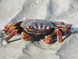
The beaches are home to crabs and endangered sea turtles like the Green
Turtle (Chelonia mydas) and Olive Ridley Turtle (Lepidochelys
olivacea), though sightings are rare. The estuaries serve as feeding
grounds for migratory birds like plovers, sandpipers, flamingos, and
spoonbills. Year-round residents include the Pacific Reef Egret (Egretta
gularis), Caspian Tern, and Whiskered Tern.
3. Wildlife of Central Hingol Floodplains and Riverbanks
This area includes floodplains, tamarix vegetation, and tree-rich
habitats. Wildlife includes:
- Birds: Spotted Owlet, Sindh Woodpecker,
Rufous-tailed Shrike, Grey Heron, and the critically endangered Sociable
Plover.
- Reptiles: Marsh Crocodile, Indian Water Monitor (Varanus
bengalensis), and Baloch Green Toad.
Human activity and flooding have reduced populations of lizards, rodents, and predators like leopards and jungle cats.
4. Wildlife of V-shaped Mountains and U-shaped Gorges
The V-shaped mountain walls support limited wildlife like Ibex, Black
Rock Agama, and birds of prey. U-shaped valleys with ephemeral pools provide
habitats for Chinkara, Caracal, Leopard, and partridges, although water is
scarce.
5. Wildlife of Eastern Mountains
This lesser-studied area, including Pachhri, Sarhad, and Deo-Beharo
valleys, has potential for diverse wildlife. Notable species include Urial,
Hyena, and Leopard. Chinkara populations are nearly extinct, requiring
reintroduction for ecosystem restoration. Key wildlife corridors connect this
area to surrounding valleys and ridges.
6. Microhabitats
Key microhabitats include:
- Sand Dunes: Provide habitats for rodents and
lizards.
- Ephemeral
Pools: Essential for
crocodiles, fish (e.g., Mahseer), and birds.
- Caves: Limited but home to bat populations
(e.g., Dhrun Mountain).
Marine microhabitats like coral reefs and littoral zones are vital for aquatic species.
Human activity, habitat destruction, and natural disasters (e.g.,
floods) have greatly impacted the park's wildlife. Restoration efforts,
including reintroducing species like Chinkara and enhancing water resources,
are critical to preserving the park's rich biodiversity.
1.4 Human Population
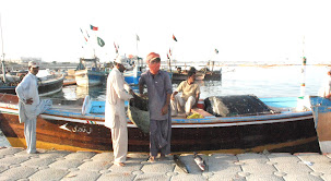
The park’s population of 5,600 individuals, consisting of about 1,000
families, resides in small tribal communities, primarily engaged in fishing,
herding, and subsistence farming. Tribal groups such as Degarzai, Kurd, and
Bizanjo are present.
Key settlements include:
- Interior
communities in Central
Hingol, Northern Plains, and Tranch Valley.
- Coastal
communities, notably in
Kund Malir, Sangal, and Malan areas.
2. Management Issues and Development Options
2.1 Challenges
- Wildlife
Conservation: Decline in
species due to habitat degradation, hunting, and reduced prey
availability.
- Human-Wildlife
Conflict: Overgrazing,
livestock intrusion, and predator attacks create conflicts with custodial
communities.
- Infrastructure
Development: Projects
such as the Makran Coastal Highway and industrial activities pose threats
to natural ecosystems.
- Lack of
Resources: Limited
funding, trained personnel, and research facilities hinder effective
management.
- Tourism
Impacts: Increased
visitation, especially for spiritual tourism at Hinglaj, is causing
overcrowding and environmental stress.
2.2 Development Opportunities
- Ecotourism
Potential:
- Coastal and
marine ecotourism in Kund Malir and Malan.
- Wildlife
viewing in areas like Machi and Hinglaj.
- Pilgrimage
tourism focused on Hinglaj Mata shrine.
- Research
and Education:
- Establish
research stations in Pachhri Valley and Rodani Kacho.
- Develop an
information center and educational programs at Aghore.
- Rewilding
Initiatives:
- Reintroduce
species like Chinkara Gazelle and Wild Donkey.
- Protect
wildlife corridors and core habitats.
- Community
Development:
- Empower
local custodial communities through vocational training, eco-tourism, and
game management.
- Promote
differential development to reduce over-reliance on park resources.
3. Management Prescriptions
3.1 Zoning and Core Areas
- Core Areas: Strict protection zones include:
- Kund Malir
estuary and coastal plains.
- Rodani
Kacho, Upper Pachhri, and Gurangatti-Hinglaj areas.
- Buffer
Zones: Four game reserves
outside the park—Sangori, Sarhad, Washiab, and SarBhat-Ballard—will
integrate sustainable use activities.
3.2 Wildlife Management
- Protection
Measures:
- Enforce bans
on hunting and overgrazing in core zones.
- Fence valley
entrances to exclude livestock.
- Species
Reintroduction:
- Reintroduce
Chinkara Gazelle in Pachhri Valley and coastal Sappat.
- Establish a
safari area around Chandragup mud volcano.
3.3 Tourism Development
- Infrastructure:
- Develop
eco-lodges and camping facilities at Kund Malir and Qadu Goth.
- Construct an
Alexander the Great historical safari route.
- Activities:
- Dolphin and
whale watching, hiking, and birdwatching.
- Educational
tours for schools and tourists.
3.4 Research and Monitoring
- Research
Focus: Monitor
populations of Ibex, Urial, Chinkara, and large predators.
- Collaboration: Partner with academic institutions,
NGOs, and tour operators for conservation and education initiatives.
3.5 Community Integration
- Custodial
Community Role:
- Employ
locals as community game watchers and eco-tourism guides.
- Establish
village conservation funds.
- Education
and Training:
- Provide
vocational training and establish primary schools.
- Encourage
alternative livelihoods to reduce dependence on livestock grazing.
Overall
The Hingol National Park Management Plan offers a comprehensive
framework for conserving biodiversity while integrating socio-economic
development. By focusing on habitat protection, species reintroduction,
ecotourism, and community involvement, the park can sustain its ecological
integrity and contribute to regional development. Collaborative efforts and
adaptive management are essential to ensure the park’s success as a natural and
cultural treasure of Pakistan.
The Author was part of Hingol National Park “ Protected Areas Management
Plan and implementation team” during 2005-2006.


